The day after visiting the Brazil side of Iguazu Falls, I explored the Argentinian side. This side has less of the river volume, but contains around 80% of the individual falls (out of around 270). What this means is, viewing the falls in their entirety is much harder from this side as you get a much wider vista, but you get to see many of the falls themselves in much detail. Specialist, rather than generalist.

Overview of the Devil’s Throat from the Argentinian side of Iguazu Falls NP.
Obviously visiting Iguazu Falls was one of the main reasons for coming to this part of South America in the first place. I’ve always had a passion for waterfalls, having been to not just sizeable ones like Victoria and Niagara, but many others from Ghana and Togo, to China, to small ones in Scotland. Iguazu though is one of the most famous and largest – indeed its name comes from the local Guarani words “y” (kinda pronounced ‘ih’), meaning “water”, and “ûasú” (‘wa-su’), meaning “big”.
How to get a ticket for the Argentinian side of Iguazu Falls
I bought my ticket for the Argentinian side of the falls at the main entrance gate. This was because I had enough Argentinian Pesos in cash, it was my last full day in the country, and the currency is essentially worthless outside Argentina because it’s awfully hard to exchange. Because no-one wants it. I know you can buy a ticket both from the official NP website and at the gate using a card though.
I don’t remember how much my ticket cost, but I think it was either 30,000 or 40,000 Pesos. It doesn’t really matter because according to their website, the price for foreigners has now risen to 45,000 Pesos, or about £34.50. Compared with the Brazilian side it’s a lot more expensive – you get a lot more, for sure, but it’s another example of how much more expensive Argentina is compared with its neighbouring countries, just like I found with the Jesuit Missions.
How to get between the Argentinian side of Iguazu Falls and Puerto Iguazu
Regular buses go between Puerto Iguazu bus station and the Argentinian falls. These leave from the nearest bus stand to the side entrance, opposite the ticket booths, and are timetabled to run every 20 minutes. You can buy tickets from the booth or from the bus driver – they were, at the time of my trip in October 2024, 10,000 Pesos for a return ticket. You get two identical paper tickets; the driver stamps or rips one, and you keep the other for the way back, despite the ticket saying it’s ‘from’ Puerto Iguazu.
Coming back from the falls, the stop is on the right as you leave the terminal building, just follow the road until you come to the sign that shows the timetable. Again buses back run every 20 minutes for the majority of the day; the first bus is at 7.15am and the last at 8.15pm. On special days with night tours, where you can see the full moon from inside the National Park, buses run much later into the evening. You;’d need to enquire about those yourself; they weren’t on my radar.
How do you get to the falls themselves?
Unlike the Brazil side, the Argentinian side is non-linear. There is a long trail up to the Devil’s Throat, but there are also two other marked trails that run alongside some of the smaller cascades, as well as a couple of smaller specific rainforest trails. In addition, there is a train that takes you to close by the Devil’s Throat.

The engine of the train that takes you to the Devil’s Throat.
This is a small tourist train which you can get tickets for at the info desk not far past the entrance to the National Park. In fact there are two stations close by each other, both badly-named, which you can get tickets at; Estacion Central is the one at the entrance, while Estacion Cataract is more … central. And not near the cataracts. From the Cataract station the train plods on for another 15-20 minutes or so through the rainforest, and running alongside the river though you can’t really see it in all its glory that well from here, until it reaches the end of the line at Estacion Garganta, This is the station for the Devil’s Throat, accessible down a 1,100m boardwalk trail.
Tickets for the train are included in the entrance fee. They’re ‘timed’, so in principle you can only take the train that departs at the time listed on your ticket. You’re also assigned a carriage, though not a seat, and when the train boards at Estacion Central, it does so in carriage order. When the train boards at Estacion Cataract, there’s separate queues for each of the carriages. In practice, the train I caught was either over-filled or people just boarded the wrong carriage so I ended up being somewhere quite different to where I was supposed to be. It didn’t matter.

Inside the train that takes you to the Devil’s Throat.
The train is made of several carriages. These are small, wooden, and open-sided above the waist, but with a roof standing on struts. The doors open and close like gates. It gives quite an old-fashioned vibe that would have been completed had the engines been steam ones. They aren’t. The train is supposed to run at no more than 5km/h, but given it overtook me while I was walking, I assume it went faster.
There is actually a mysterious fourth station, a little way beyond Cataract on the way to Gargantua. This is called Tres Maria, and trains don’t normally stop there. This is a specific point on the river where scientists, and presumably documentary makers, can take specialist boat trips into the river to explore the wildlife. It’s generally not for public use.
As a side note, all the boarding and journey announcements were entirely and only in Spanish.
The Devil’s Throat Trail
After deboarding at Gargantua Station, there’s little else to detain you except take the trail to the eponymous Devil’s Throat. This is a 1,100m walk along a zigzagging boardwalk that stretches far out into the river. It passes over lots of the different channels the water flows through, and over and past rocks and small islands that delineate them. There’s also a lot of clumps of trees visible as you walk, almost giving the vibe of a flooded forest.
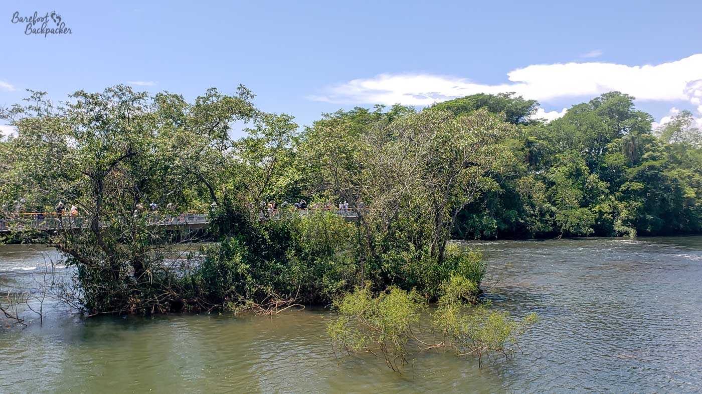
View from the boardwalk to Devil’s Throat.
Despite all the other parts and hikes on this side of the falls, this is the bit that everyone comes to see. As such, even the boardwalk path is a constant stream of people walking in both directions. It makes it awkward to stop and take pictures of the river’s flow, but people do. And of course despite the widening of the path at the Throat itself, despite the theoretical one-way system in operation around the block designed so everyone can get a view of it from several directions and viewpoints, it’ is a somewhat chaotic mass of bodies standing by the fence for probably longer than they ought to be, taking pictures and selfies of everything and in everyway. If you’re tall you can stand a row or so back and take pictures with an up-stretched arm, but then you’re partly in the way of people walking behind you to find a better position.

The boardwalk to Devil’s Throat proved very popular on my visit. Instagram v Reality this is not!
That description might all sound negative and over-touristy, however remember that some places are popular for a reason. Once you manage to push your way to the metal fence and look out at the falls, you’re greeted with one of the most spectacular sights you’re going to see. Although your mileage may vary as to whether the view from the Brazilian side is better. Do both, and let me know.

Close-up of Devil’s Throat.
It’s a wall of water. It’s a stereo soundscape of rushing and crashing. It’s a misty spray that makes your pictures a bit grey – indeed it makes it a little hard to see through the screen to what you’re taking a picture or video of, so you just have to hope you’ve got the right angles, even if there was no-one else in the way. Everything you own will get slightly damp, but in person it adds to the effect. It would be so easy for a phone to slip away from a moist hand; that would be unfortunate. You can feel the power of the water and it’s so easy to just lose yourself in time.

Another close-up of Devil’s Throat. The misty nature is not a camera artefact (well, it is, but also), it’s because there was so much spray in the air. I’m impressed I even took the photos reasonably well given I could barely see what I was doing.
But then you’d be in the way. So it’s time to move on to somewhere a little quieter.
The Upper and Lower Trails
From the Cataract Station there are two trails that visit a lot of the smaller cascades. These are visible in their entirety from the Brazilian side, but here you can see each of them close-up at an individual level.

Many of the smaller waterfalls, seen fairly close up.
The two trails are called the Upper and Lower Trails, and they pretty much do exactly what they say on the signposts. The Upper Trail runs along the top of the falls, so you see them from above and watch the water flow along and then down them. Conversely the Lower Trail view them from below, so you can see the actual cascading of the water straight-on. They both are worth the trek, as it’s quite interesting to see the same falls from different angles. The majority of both trails are on purpose-built boardwalks.

It’s not often you get quite this close to the top of a waterfall that’s that big.
The waterfalls they go past are quite powerful in and of themselves, and even if the Devil’s Throat didn’t exist, they’d still very definitely be worth seeing. Each of the individual falls has its own name, including Salto Dos Hermanas (two sisters), Adan y Eva (Adam and Eve), and a couple named in memory of National Park Rangers who have died on the job.

Wider view of the river chasm. Notice the rainbow?
The Upper Trail is the longer of the two, at 1,550m, and is the only one of the two that’s fully accessible (no stairs, just ramps). It heads South, in the direction of the Devil’s Throat (and you can see the spray coming off it in the distance), and includes a side-trail to the San Martin waterfall, overlooking the namesake island. You used to be able to get onto the island itself but this doesn’t seem to be an option at the moment (and hasn’t for a while). The Lower Trail is a little shorter, at 1,400m, and has more steps, but also takes a direct route to the river so goes past a couple of falls only otherwise visible from the Brazilian side (Lanuz and Alvar Nunez), before heading past San Martin island and being able to view the waterfalls on the Upper Trail from a distance.
Other Trails
There’s three other trails to note, although one of them isn’t very long. At 650m, the Green Trail is the designated walking path between the Centrale and Cataract Stations. It doesn’t follow the railway, although it does cross it close to Cataract station; rather it takes a more direct route through the rainforest, and past some more open swampland. There’s signs saying ‘beware of the wildlife’, including cheetahs; I saw only a lizard. Once.

The Green Trail. Does exactly what it says on the signpost.
There is a trail that does follow the railway though – it runs from Cataract to Gargantua Stations. It’s not listed as a separate trail on the map, nor is its distance marked, and it’s mainly used as an access road for local staff to reach the Devil’s Throat and Tres Maria areas. When I was on the train to Gargantua though, I did pass a couple of small groups walking up that way, and at both stations it is signposted, so it’s clearly a designated trailway. I myself took it back to Cataract once I’d seen the Devil’s Throat. It is quite long though, probably about 3-4km, and not something you really want to be doing in the middle of the day.

The path to the Devil’s Throat station that runs alongside the river and the railway.
It’s quite different to see this bit of the rainforest from the ground rather than the train; it means you get to spot locations like the many turtle crossings. The track is built over the route of, specifically, Williams Side-Necked Turtles as they head between the river and the forest, so many small tunnels have been built below the tracks to allow them to cross. Sadly I did not see any, but I wasn’t visiting at the right time of year – while laying season is September to April, hatching season, when I guess you’ll see many more of them, is December to February.
Finally, the map also indicates a trail to the river called the Sendero Macuco. This is a 7km loop that runs from near the NP Entrance, so quite downriver of the falls. It’s another mainly rainforest trail that I chose not to do because I’d already done all the other trails and therefore seen quite enough of it.
What else is there to do at Iguazu Falls?
I didn’t visit any of the restaurants or shops on my visit – I didn’t feel the need to and besides they vibed a bit overpriced – but around both the Centrale and Cataract Stations there’s a handful of both – more at Centrale by the entrance in fact. There’s also a small food court just past Cataract Station by where the Upper and Lower trails split off. On the way there there’s a water tap and shower that’s quite popular to fill up at (and play in). Also in the area around where the trails split is a hotel, and a weird lighthouse-like building hidden in the trees that did not seem to be open on my visit.
You can also arrange boat trips to see the falls from river level but honestly given the number of rainforest and waterfall trails here, that’s probably better off being booked from the Brazilian side where you’ll have more time.